Gravel Grinding -Taking the (dirt) road less traveled
02/22/2014 02:45PM ● By Grant Johnson
Photo courtesy Moots
By Jon Cariveau
There is a big boom in road cycling around Steamboat Springs and Routt County. Paved routes have seen more maintenance and our population is aging a bit, making mountain biking more of a risk. With road cycling you can cover more ground in a given time.
Those paved routes are wonderful, but what about looking at local roads beyond where the pavement ends?
First, you’ll see gravel. Maybe even some smooth-packed dirt. Our corner of Colorado is covered in county-maintained dirt roads that, depending on the time of year, can offer terrain ranging from super-smooth-like-pavement to a bit of gravel and pot holes. Beyond county roads are the U.S. Forest Service roads that run into and through National Forest land. These dirt roads open up new loops that can be connected via pavement. With the right mindset and a little change in equipment, you can set yourself free from just riding pavement.
Get up close and personal with the Sleeping Giant. See the “backside” of Emerald Mountain. Experience the amazing sights, sounds and smells of open space and local ranches as the miles tick away with each pedal stroke. Venture farther into the county, challenge yourself and enjoy rides with fewer vehicles as you discover what lies beyond your usual route.
The Routt County road map holds the keys to roads you may never have known were there. A sense of exploration is needed, along with a creative water supply. As always, obey the rules of the road, be safe and be prepared – and away you go.
Here are two favorite Routt County mixed-surface road rides. If you’re not riding from home, a good start point option is park at the Stockbridge Center, west of downtown Steamboat on U.S. 40.
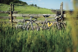
Photo courtesy Moots
Route #1: Sleeping Giant/Deep Creek Loop
40 miles/20 miles on gravel roads/2,200’ of vertical climb
Take U.S.
40 WEST from Steamboat for 3 miles
RIGHT on County Road 42
RIGHT on County Road 44
LEFT on County Road 46
CONTINUE bearing RIGHT on County Road 52
CONTINUE bearing RIGHT on County Road 52W
CONTINUE bearing RIGHT on County Road 56
CONTINUE bearing RIGHT on County Road 54
RIGHT on County Road 129
VEER Right on County Road 44A
LEFT on County Road 44
MERGE onto County Road 129
Follow County Road 129 (Elk River Road) down airport hill back to town
Route #2: Emerald Mountain Loop
30 miles/6 miles on gravel roads/ 1,700’ of vertical climb
Head out
on County Road 33 (Twentymile Road), starting at 13th Street,
downtown
LEFT on County Road 43 (gravel begins here)
BEAR RIGHT onto County Road 41
LEFT on County Road 35
LEFT on County Road 14 (River Road), heading back to downtown
Jon Cariveau is the marketing manager for Moots. He's an avid cyclist with a special affinity for Cyclocross. Moots is organizing a non-competitive Gravel Grinder event scheduled for mid-June 2014. Visit moots.com for details.
Here are two great resources to map your gravel grinding adventures.
http://www.co.routt.co.us/index.aspx?nid=95
http://steamboatbiketown.com/riding-maps/road/